
Saguaro National Park, Tucson
Hell’s Hole, Havasu, Humphreys Peak ... the best hikes usually save the best for last, with scenic payoffs such as waterfalls and tundra summits. That’s not the case on the Hope Camp Trail. Instead, the reward is all around you, courtesy of Mother Nature, the National Park Service and the Wilderness Act. Although the trail itself is located entirely within Saguaro National Park, most of what you’ll be seeing to the north and to the east is the protected landscape of the Saguaro Wilderness and the Rincon Mountain Wilderness. It’s not the best-known trail in the Tucson area, but Hope Camp winds through a gorgeous section of the world’s most beautiful desert.
The hike begins at the Loma Alta Trailhead, which is located off a dirt road along the southern boundary of the park. About 30 yards from the lot, you’ll come to a steel gate and a sign that warns about the Africanized honeybees and mountain lions in the area. Desert tortoises are out there, too. Chances are, you won’t see any of the above; however, you might see cactus wrens, roadrunners, red-tailed hawks and pinyon jays. And in the spring, you’ll almost certainly see wildflowers, including wild hyacinths, lupines and Mexican goldpoppies.
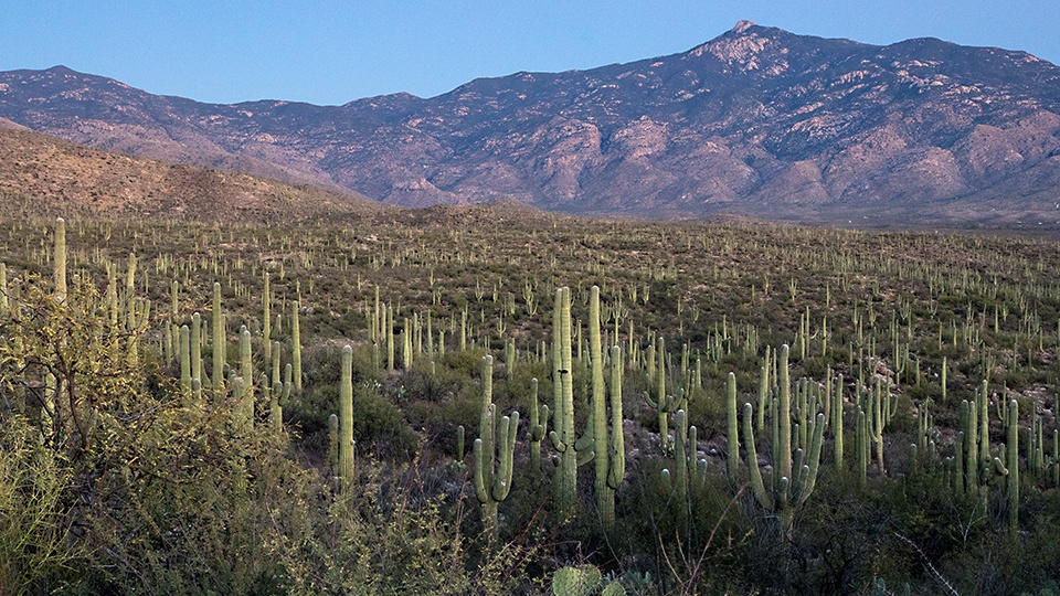
From the gate, the trail climbs slightly through a scene that’s typical of the lower elevations of the Sonoran Desert: prickly pears and saguaros mixed with mesquite trees and paloverdes. Within a minute or two, you’ll come to an intersection with the Ridge View Trail, which veers north for about a mile and offers some great photo ops. It’s a worthy side trip, if you have the time. Otherwise, continue on. About five minutes later, you’ll get a good look at where you’re headed. As you scan the horizon from west to east, you’ll see Tanque Verde Peak, Mica Mountain and Rincon Peak. And at their feet lies the Rincon Valley, which is like a greenhouse for giant saguaros.
From the lookout, the trail descends to a riparian thicket in the floodplain of Rincon Creek, where it intersects the Coyote Wash Trail. About 10 minutes later, it arrives at what’s left of Deer Camp. You’ll know you’re there when you see a groggy Aermotor windmill and a rusted water tank. Deer Camp was one of several line camps used by cowboys from area ranches, including the Rock-ing X and X-9. Long before the cowboys, in the 13th and 14th centuries, the Hoho-kam people lived in the same area, harvesting saguaro fruit and mesquite beans, and hunting deer and bighorn sheep.
Back on the trail, just beyond the camp, keep your eyes peeled for a “crested” saguaro, which is identified by a fan-shaped mutation at the top of the plant. Scientists estimate there are fewer than 700 crested saguaros in the world. Not far from the rare cactus is an intersection with the Ruiz Trail, which is another nice diversion. More impressive, however, is the growing number of giant saguaros and your proximity to them. They’re spectacular, and you’ll be close enough to rub elbows.
The saguaros are the highlight, but the trail itself is impressive, too. It’s an old jeep road- built by cowboys, and it makes a great path for hiking and mountain biking — Hope Camp is one of the few trails in Saguaro National Park that’s open to bikes. Although it’s important to share the trail, you won’t see a lot of traffic. Still, beware.
Moving on, the terrain remains about the same as you work your way to an intersection with the Quilter Trail, which is named for John James Quilter, a Park Service ranger who died on the trail in 2006. The Quilter Trail veers north to Manning Cabin and serves as a segment of the Arizona Trail. But you won’t have time for that, so veer right and continue on the Hope Camp Trail, which, at this point, also overlaps the Arizona Trail. In the homestretch, you’ll get some nice views of the Santa Rita Mountains to the south and more spectacular desert vegetation — the prickly pears put on quite a show in this area.
Like Deer Camp, you’ll know you’ve arrived at Hope Camp when you see an old windmill and other remnants of cowboy life. None of what you’ll see is as exciting as a waterfall or a tundra summit, but that’s not why you hiked this trail. You hiked it for an easy stroll in a gorgeous section of the world’s most beautiful desert.
Length: 5.6 miles round-trip
Difficulty: Easy
Elevation: 3,107 to 3,290 feet
Trailhead GPS: N 32˚07.977', W 110˚41.223'
Directions: From the Saguaro National Park visitors center (Rincon Mountain District), go southeast on Old Spanish Trail for 7 miles to Camino Loma Alta. Turn left onto Camino Loma Alta and continue 2.4 miles to the trailhead (the last half-mile is a dirt road).
Vehicle Requirements: A high-clearance vehicle is required on the last half-mile.
Dogs Allowed: No
Horses Allowed: Yes
USGS Map: Tanque Verde Peak
Information: Saguaro National Park, 520-733-5133 or www.nps.gov/sagu