
Picacho Peak State Park, Casa Grande
On paper, Picacho Peak isn’t very impressive. It’s hardly the highest peak in Arizona. In fact, based on a U.S. Geological Survey search, there are at least 2,500 other summits ahead of Picacho. Nevertheless, it’s a peak worth bagging. If for no other reason than to conquer the most recognizable landmark between Phoenix and Tucson.
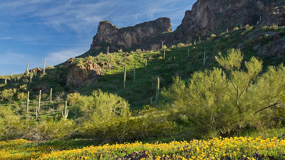
The Hunter Trail, which is one of five in Picacho Peak State Park, is the route to the top. With your first step from the trailhead, you’ll start a gradual climb up a rocky slope dotted with saguaros, creosote bushes and paloverde trees. In March and April, you’ll see wildflowers, too, including Mexican goldpoppies, lupines, globemallows, desert chicory and brittlebush. The flowers look great on Instagram. And they also help mitigate the droning of the 18-wheelers in the background.
Although the park would be more parklike without the interstate traffic, Picacho Pass has been a crossroads of sorts throughout history. The peak itself, which is visible for many miles in every direction, was used as a navigational landmark by early explorers such as Father Eusebio Kino and Juan Bautista de Anza. The old mail road passed through here, as well, and so did the Butterfield Overland route. So, the traffic today is just an extension of the past. That said, it’s OK to use an iPod on this one.
Continuing on, about 10 minutes in, the well-groomed trail steepens and segues into some short switchbacks. The track here turns to bare rock lined with cables to make the climb a little easier. There are more cables to come — cables that make this first set look superfluous — so you’ll want to pack a set of durable gloves. Leather work gloves work best.
As you maneuver past the cables, the trail becomes less of a trail and more of a rock scramble. It’s not extreme, but you should know it’s coming. Ten minutes later, you’ll arrive at what looks like a trail intersection. It’s not. To the right is a short spur that leads to a nice overlook. Instead of right, you’ll go left and eventually arrive at “the great wall of Picacho” — that’s not an official name, but it should be.
From there, the trail levels off a little and quickly arrives at the mountain’s saddle (elevation: 2,960 feet). This is where the Hunter Trail transitions from the north side of the peak to the south. The south side was built first, by the Civilian Conservation Corps, to service a 40-foot light beacon that was installed at the top of the peak for air traffic control. That was in 1932. The north side was built in 1965, when Picacho Peak and its surroundings became a state park.
There’s a sitting bench at the saddle, which is a good place to catch your breath after climbing almost 1,000 feet. Unfortunately, you’ll lose a good chunk of that elevation as you continue down the trail. Yes, down. From the saddle, the trail drops steeply for several hundred feet. There’s another cable to help with the descent, which you’ll want to do backward, in a rappelling motion. Just be careful.
About 10 minutes later, you’ll come to an intersection with the Sunset Trail. Stay left and continue uphill through another moderately technical area and some rocky switchbacks. Then, after 45 minutes of overall hiking, things get intense — think more cables and steep drop-offs. This is the turnaround point for anyone with acrophobia.
Although it’s not as nerve-wracking as the tightrope on Angels Landing in Zion National Park, the course of vertical ascents and narrow rock ledges from this point to the top will test your mettle. It’s dangerous, but as long as you pack a thinking cap and watch your step, you’ll be fine. And once you’ve topped out on the Hunter Trail, you’ll feel like you’ve accomplished something. Regardless of what it looks like on paper.
Length: 4 miles round-trip
Difficulty: Strenuous (and technical)
Elevation: 2,007 to 3,374 feet
Trailhead GPS: N 32˚38.558', W 111˚24.150'
Directions: From Casa Grande, go east on Interstate 10 for 29 miles to Picacho Peak Road (Exit 219). Turn right onto Picacho Peak Road and follow the signs for 0.4 miles to the entrance station for Picacho Peak State Park. From there, continue 0.2 miles to the Barrett Loop, turn left and continue 0.3 miles to the trailhead.
Special Consideration: Arizona state park fees apply.
Vehicle Requirements: None
Dogs Allowed: Yes
Horses Allowed: The trail is unsuitable for horses.
USGS Map: Newman Peak
Information: Picacho Peak State Park, 520-466-3183 or azstateparks.com/picacho