
Navajo Nation
The drive to Canyon de Chelly can be deceptive. When you eyeball the route on a map, you can see it’s off in the distance, but it doesn’t seem that far off. That is, until you start driving. Still, it’s worth the effort. The long trek to this add-it-to-your-bucket-list-now national monument cuts through the heart of red-rock country on the Navajo Nation, and the scenery is spectacular.
Begin the drive at the Canyon de Chelly Visitor Center, just east of Chinle. From there, head out on Indian Route 64 toward Tsaile and the north rim of Canyon de Chelly. The road skirts the canyon, but, unlike the south-rim drive, you won’t see much from the road. There are, however, three overlooks that offer great views of Canyon del Muerto’s ancient ruins and striking cliff walls.
Around Mile 21, you’ll arrive at the top of a hill where you’ll see the Lukachukai and Chuska mountains in the background. Three miles later, you’ll reach a “T” junction. This is your cue to turn left onto Indian Route 12.
For the next 8 miles, watch your speed — horses and dogs tend to linger along the road. Although there isn’t a sign to indicate that Indian Route 13 will be coming up on your right, the turnoff is at the 32-mile mark of the drive. As you pass through the community of Lukachukai, you’ll cross Totsoh Wash, which looks more like a trickle, despite the relatively lush riparian area it feeds. The payoff here is a panorama of red rocks that resemble carved, horizontal waves.
Continuing on IR 13, the road shifts from mostly flat terrain to steep, tight switchbacks. If you’re a passenger, your first inclination might be to close your eyes. Don’t. Yes, the incline is a little intense, but the views are beautiful. Sagebrush and piñon pines give way to ponderosas and aspens, and at Mile 45, the views of red-rock country get even better.
Eventually, the road starts to descend — minus the winding switchbacks — and arrives at Red Rock Trading Post, which is a good place to fill up or stretch your legs. At this point, you can either turn back and retrace your route or continue on to the remote community of Cove. Surrounded by the Lukachukai and Carrizo mountains, the area is wonderfully scenic, with red-rock formations erupting from the vast, unfolding landscape.
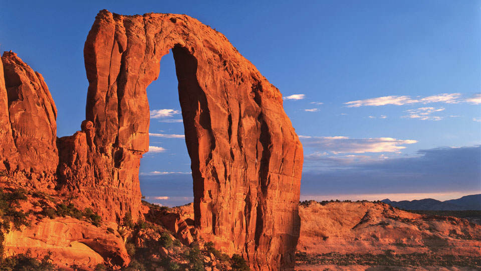
The turnoff to Cove is unmarked, but it’s the first left after the trading post on Indian Route 63. From there, make another left onto Indian Route 33. As you meander along, roll down your window and enjoy the views. After 13 miles, the pavement ends, marking the turnaround point. On the way back, the perspective is different, and it’s grand. On your left, look for Royal Arch. There’s also a nice view of Ship Rock in the distance — across the Arizona-New Mexico border. Although Chinle and Cove are a long way from where you started, you’ll be glad you made the trip.
Note: Mileages are approximate.
Length: 70 miles one way
Directions: From the Canyon de Chelly Visitor Center, turn right onto Indian Route 64, which veers to the left (follow the sign to Tsaile and the north rim of Canyon de Chelly), and go 24.4 miles to Indian Route 12. Turn left onto IR 12 and continue 8 miles to Indian Route 13. Turn right onto IR 13 and continue 24.5 miles to Indian Route 63. Turn left onto IR 63 and continue 0.5 miles to Indian Route 33. Turn left onto IR 33 and continue 13 miles to the turnaround point.
Vehicle requirements: The route is suitable for standard sedans, but traveling in inclement weather requires a four-wheel-drive.
Information: Canyon de Chelly National Monument, 928-674-5500 or www.nps.gov/cach
Travelers in Arizona can visit www.az511.gov or dial 511 to get information on road closures, construction, delays, weather and more.