
Williams to Jerome
Mountain man Bill Williams, rancher Marion Perkins and investor Eugene Jerome never met, but they're connected by two things. The first is that they all lent their names to Northern Arizona burgs. The second is the wildly scenic Perkinsville Road, which slices through the historically well-trodden, currently forgotten countryside between their namesake towns.
Williams — a rough-and-tumble ranching, lumber and railway center appropriately named after a rugged adventurer — fell into decline in the last century. Twice. First, with the demise of the Atchison, Topeka and Santa Fe Railway; second, when it became the last Historic Route 66 town to be bypassed by Interstate 40. Currently, as the southern terminus of the Grand Canyon Railway, it’s experiencing a minor renaissance.
Begin this 47-mile drive in the colorful historic district of restored saloons and bordellos, heading south on Fourth Street, which becomes Perkinsville Road, also marked as County Road 73.
The first stretch meanders through the Kaibab National Forest, passing the occasional llama ranch and aspen grove. At about 11 miles, the elevation slowly decreases, and with it, the height of the pine trees, which now mingle with juniper, oak and mesquite. Flat-topped Mingus Mountain looms into view, seeming so far away it’s hard to believe it’s your destination.
Once you leave Coconino County and enter Yavapai County, the road becomes County Road 70. At 24 miles, the pavement ends, but the road is still suitable for a regular passenger vehicle in good weather. After 3 miles on the dirt road, turn right onto County Road 72 (still Perkinsville Road), which wends its way toward Perkinsville.
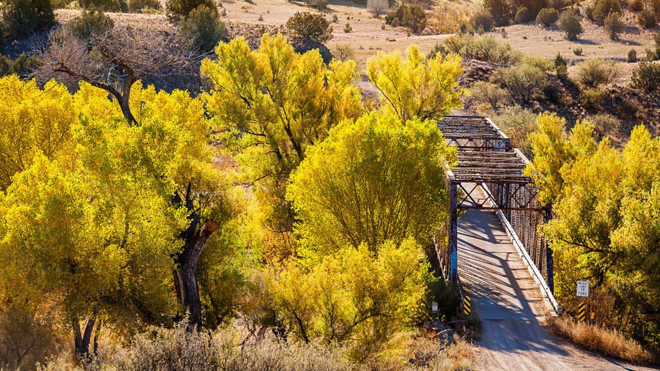
Despite earning a dot on a map, Perkinsville is not so much a town as … well, a ranch. But what it lacks in population, it makes up for in big scenery. It’s easy to see why, in 1900, the Perkins family put down roots in this pastoral landscape of grama grass backdropped by endless blue sky. The perennial Verde River burbles through, flanked by cottonwoods that, in the fall, resemble giant yellow cauliflowers.
You’ll traverse the one-lane Perkinsville Bridge — the most reliable crossing on the Verde River, and a put-in point for rafters. A sign directs you to Jerome along much the same route as the one the Perkinses used to transport their beef to feed the town’s miners in the early 1900s. Past Perkinsville, the landscape becomes a dry series of gray hillocks patched with yellow grasses and spattered with juniper.
Shortly, the road turns and changes dramatically. These last few miles are not for the acrophobic or lead-footed. You’ll be negotiating a winding, gravelly one-lane road carved out of the hills that follow the old bed of the United Verde & Pacific Railway. There’s no guardrail to prevent cars from plummeting off the cliff, which is frustrating, given the views that tempt your eyes off the road. The whole valley spreads out below, with beige hills undulating into Sedona’s red rocks and Humphreys Peak standing blue on the horizon. Then there’s the unique opportunity of approaching the mile-high hill town of Jerome from above.
New York investor Eugene Jerome never saw his namesake town — not when it was teeming with miners and prostitutes at the turn of the century, and certainly not these days, when it’s teeming with artists, tourists and flotillas of Harley-Davidsons.
Like the town of Williams, Jerome is a wild child made good, a Western town that’s followed a familiar boom/bust/baby-boom pattern. We’ll never know what adventurous trapper Bill Williams, pioneering rancher Marion Perkins and copper-mining mogul Eugene Jerome would think of the decline of their industries and the taming of this chunk of the Wild West. But it’s something to ponder, perhaps over a famous cheeseburger at the Haunted Hamburger, where you can finally savor those valley views from the safety of the balcony.
Note: Mileages are approximate.
Distance: 47 miles one way
Directions: From Williams, go south on Fourth Street, which becomes Perkinsville Road (County Road 73) and later turns into County Road 70, for 27 miles to County Road 72. Turn right onto CR 72 and continue 20 miles to Jerome.
Vehicle requirements: None in good weather, but a four-wheel-drive vehicle is recommended during winter, when snow may be on the road, and in July or August, when afternoon thunderstorms are common.
Information: Williams Chamber of Commerce, 800-863-0546 or www.experiencewilliams.com; Jerome Chamber of Commerce, 928-634-2900 or www.jeromechamber.com.
Travelers in Arizona can visit www.az511.gov or dial 511 to get information on road closures, construction, delays, weather and more.