
Mazatzal Wilderness, Payson
If you’ve ever headed north to Payson, Pine or Christopher Creek, you’ve been past the brown road sign for the Barnhardt Trail. Like the brown signs for Kaibab Lake, Pole Knoll and other places, the Barnhardt sign doesn’t attract many customers — most people on the Beeline Highway are in a big hurry to get someplace else. The trail is worth hiking, though. It’s easy to get to, and it’s a great way to sample the Mazatzal Wilderness, which protects more than a quarter-million acres between the Salt River and the Mogollon Rim.
From the trailhead, you’ll immediately come to an intersection with the Y Bar Basin Trail, which veers left. A minute later, there’s a gate. Junipers, oaks and prickly pears fill in the space along the trail. Just beyond the gate, you’ll drop into a small wash. When you pop out, check out the views of the Mogollon Rim to the north. The views are nice.
At this point, the ascent is gradual and the trail follows a north-facing slope. Down below is a gorgeous riparian area, but you won’t fully appreciate the willows and cottonwoods until the hike back, when your line of sight is less obscured.
After about 20 minutes, you’ll come to the Mazatzal Wilderness, which was designated a forest reserve in 1908 and then a primitive area in 1938. It got its wilderness protection in 1964, and now it cradles one of the largest backcountry areas in the state. Beyond the boundary are some larger trees, including the trail’s first ponderosa. From there, the route winds around a large rock outcropping and tightropes a steep drop-off. If you look down, you’ll get a better look at the riparian area.
Continuing the climb, you’ll start seeing manzanitas. The first of many. The trail then crosses an exposed slope and zigs back around a deep side canyon. “Circuitous” is a recurring theme on the lower half of Barnhardt — so many side canyons. Along one of the zigs (or zags), you’ll pass the trail’s second ponderosa and get a glimpse of where you’ll think you’re headed. That, however, is one of several miscommunications by Mother Nature on this route — she repeatedly takes you in directions you don’t expect. What is clear is the elevation gain along this stretch. The long switchbacks are steep and grueling.
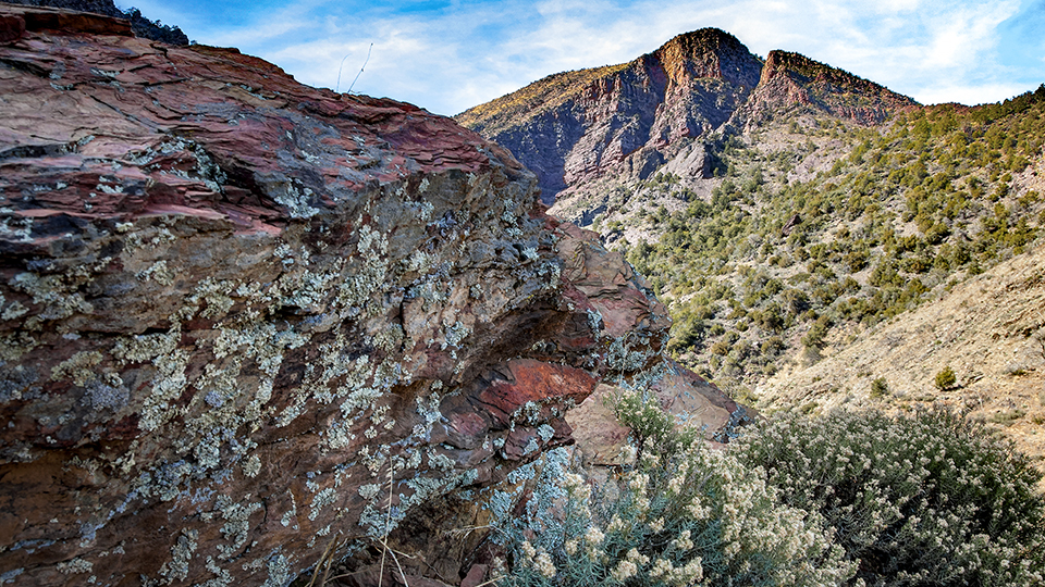
At the one-hour mark, you’ll hit the mile-high point of the hike. You’ll also see — finally — the pass you’ll be taking through the craggy mountain. Fifteen minutes later, you’ll come to a narrow side canyon of red rocks, one that funnels water to the riparian area below. Although the water isn’t perennial, when it’s running, the waterfall is a photo op.
Beyond the rocks, you’ll huff and puff to the ridge you’ve been eyeing for much of the climb. From there, the trail levels off and heads west. On the distant horizon, you can see the saddle where the trail ends. In between, the slopes are covered with manzanitas and young oaks. They’ve taken over much of the landscape in the wake of the Willow Fire, which was sparked by lightning in June 2004 and eventually consumed almost 200,000 acres.
Despite the intensity of the blaze, much of the chaparral zone has recovered, minus the junipers. Higher up, however, the skeletal remains of ponderosas are a reminder of how indiscriminate wildfires can be. Nevertheless, what you’ll see up top is a great lesson in ecology, and the hike itself is not diminished by what’s missing — the rugged mountains and spectacular panoramas are as impressive as ever.
The final approach to the saddle is a leisurely repetition of back and forth, up and down. Then, after about two and a half hours, the trail ends at an intersection with the Mazatzal Divide Trail, which also doubles as the Arizona Trail. To the north is Chilson Spring and eventually Utah. To the south is Mexico. And if you turn around and look to the east, you can see where you’ve been. You can’t see the cars whizzing by on the Beeline Highway, but you can rest assured they’re out there.
Length: 12.1 miles round-trip
Difficulty: Strenuous
Elevation: 4,184 to 6,007 feet
Trailhead GPS: N 34˚05.575', W 111˚25.329'
Directions: From Payson, go south on State Route 87 (the Beeline Highway) for 12 miles to Forest Road 419 (look for the trailhead sign on the right). Turn right onto FR 419 and continue 5.1 miles to the trailhead.
Vehicle Requirements: None
Dogs Allowed: Yes
Horses Allowed: Not suitable for horses
USGS Map: Mazatzal Peak
Information: Payson Ranger District, 928-474-7900 or www.fs.usda.gov/tonto