
Superstition Mountains, Tonto National Forest
In the 1930s, you might have seen Arthur Weber wandering around Peralta Canyon. He’d go out there looking for the mother lode. He never found it, but he did establish something that came to be known as the Dons of Phoenix — a name that honored the Spanish dons who explored the area in the 1600s. The group initially was made up of young men from the Phoenix YMCA, where Mr. Weber was the physical education director. Its purpose was to keep alive the folklore of the Southwest, and over the years, the Dons became famous for their Superstition Mountain Lost Dutchman Gold Mine Trek. In fact, it was such a big deal the U.S. Forest Service erected an official sign in Peralta Canyon marking the “Dons Club Base Camp,” which is still located about a quarter-mile southwest of the Peralta Trailhead. The sign read: “This is the starting point each year for the Dons Club Trek into the spectacular Superstition Wilderness Area in search of the Lost Dutchman’s gold mine.”
Although the Dons are still around, their annual trek hasn’t happened since 2004. That doesn’t mean the canyon is quiet, though. The Peralta Trail is one of the most popular hikes in the Superstition Mountains, especially in the springtime, when goldpoppies add a splash of color to the rugged landscape of boulders, saguaros and paloverdes.
From the trailhead, the hike drops into a riparian area and enters the Superstition Wilderness, which was designated a forest reserve in 1908 and then the Superstition Primitive Area in 1939. It got its wilderness protection in 1964 and now cradles 160,236 acres, including all of those along this trail.
After about five minutes of easy trekking, you’ll come to a small pool that’s fed by an even smaller waterfall, but only when the conditions are right. Pray for rain. Five minutes later, you’ll come to another small pool and a thicket of trees. This is where the trail begins a gradual climb. The only real challenge at the outset is an overhanging rock that will dent your forehead if you’re not paying attention.
As you climb out of the riparian area, the trail steepens and winds uphill through a canyon of boulders, some as big as small houses. To the left is a gathering of hoodoos, and all around are giant saguaros, the dominant plant species in the area.
After an hour of overall hiking, the well-worn footpath turns to flat rock. From there, the trail quickly leads to Fremont Saddle, which is the turnaround point for this hike. However, if you’re feeling ambitious, the Peralta Trail continues into Boulder Canyon for another 4 miles and connects with the Dutchman’s Trail. The extra distance turns this otherwise moderate hike into a 12.4-mile round-tripper that’ll make you sweat. But the payoff on Peralta is the view of Weavers Needle from up on the saddle.
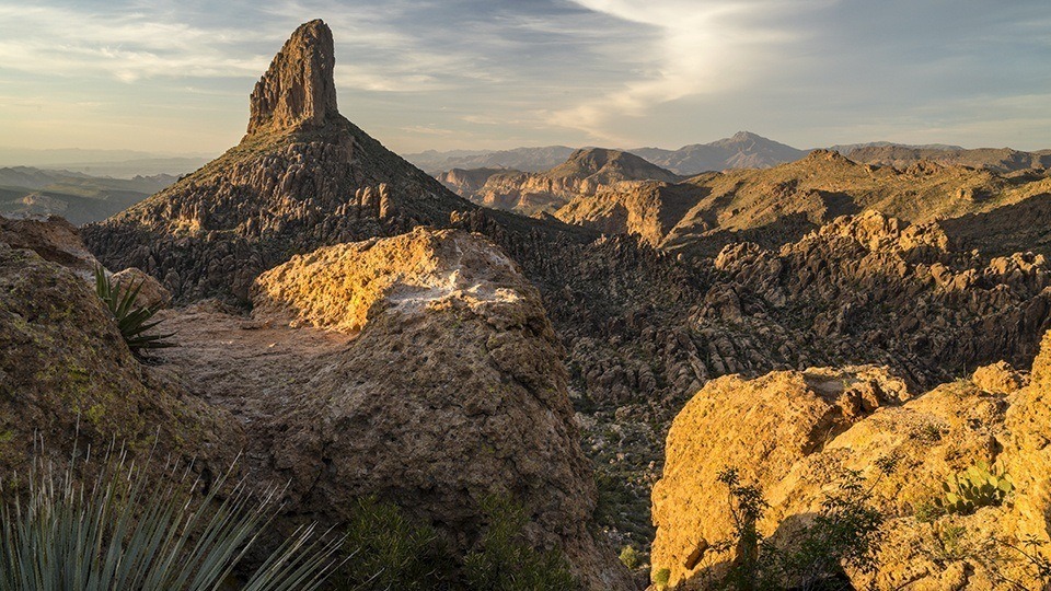
Named for Paulino Weaver, a famed mountain man, scout, trapper and miner, Weavers Needle is a volcanic monolith that rises almost 1,300 feet from its base to an elevation of 4,553 feet. It’s the most recognizable landmark in the wilderness, and it’s also considered a marker for the legendary Peralta Mine.
As the story goes, Don Miguel de Peralta and his family, who had come to the Superstition Mountains from Mexico, discovered gold, lots of gold, in the shadow of Weavers Needle. However, before cashing in, according to the story, they were killed by Apaches, who allegedly sealed off the mine. A few decades later, Jacob Waltz, better known as the “Lost Dutchman,” claimed to have found the old Peralta Mine, but he died before proving his claim. Since then, thousands of treasure hunters have gone looking, including Arthur Weber and the Dons of Phoenix, but no one has ever found the gold. And it’s unlikely anyone ever will — the volcanic rock out there isn’t conducive to producing precious metals. They’ll keep looking, though. Meantime, the real treasure is the trail. Especially in the springtime, when the ground is covered with gold.
Length: 4.4 miles round-trip (to Fremont Saddle)
Difficulty: Moderate
Elevation: 2,401 to 3,751 feet
Trailhead GPS: N 33˚23.859', W 111˚20.874'
Directions: From Idaho Road in Apache Junction, go east on U.S. Route 60 for 7.7 miles to Peralta Road. Turn left onto Peralta Road and continue 7.3 miles to the trailhead.
Vehicle Requirements: None; however, the pavement ends on Peralta Road after 0.9 miles.
Dogs Allowed: Yes
Horses Allowed: Not suitable for horses.
USGS Map: Weavers Needle
Information: Mesa Ranger District, 480-610-3300 or www.fs.usda.gov/tonto