
The mystique of the Old West leads to a lot of urban legends, including the myth that South Mountain Park is the largest municipal park in the country. It’s not. It was at one time, but that distinction now belongs to another local park, about 35 miles to the northeast. According to the Trust for Public Land, Scottsdale’s McDowell Sonoran Preserve is the Gargantua of open space, at 30,500 acres. By comparison, South Mountain Park is about 16,000 acres, which is still impressive — it’s the equivalent of 19 Central Parks. Even more impressive: The city of Phoenix bought the land from the federal government for $1.25 per acre.
At the time, the Salt River Mountain Range, as it was known then, was mostly just horizon, and South Phoenix was little more than ranchland. One of the ranchers, Dwight B. Heard, was an avid hiker who spent a lot of time on the mountain. Despite being a land baron himself, he worried that unchecked growth would swallow up his stomping ground. So, in 1920, as the owner of the state’s largest newspaper, he used his bullhorn to push for preservation. A few years later, in June 1924, President Calvin Coolidge sold the lush desert land to Phoenix so that it could be set aside as a city park, even though it was a long haul — 8 miles — from the heart of the city. Thank you, Mr. Heard.
Today, the park is a magnet for hikers, bikers and horseback riders who use the 50 miles of trails as a quick getaway from the grind. In all, there are 29 routes in the park, ranging from a few half-mile hikes to the 14.3-mile National Trail, which is one of two ways to get to the Hidden Valley Trail — the other option is the Mormon Trail. Either one will work, but the National offers better views and includes the scenic drive to the top of the Guadalupe Range, which is one of three ranges that converge in the park. The other two are the Ma Ha Tauk and the Gila.
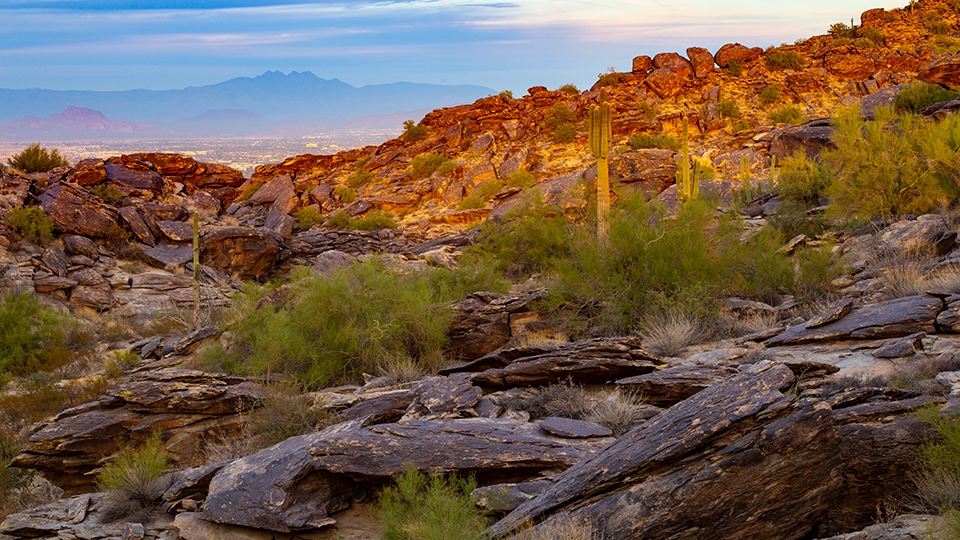
From the Buena Vista Lookout, the National Trail begins a mild descent on a well-defined track of rock and dirt. To the left is a long-distance look at downtown Phoenix. And farther on, you’ll see Piestewa Peak and Camelback Mountain. Like most trails in the Sonoran Desert, this one cuts through an ecosystem of saguaros, octotillos, chollas, prickly pears and barrel cactuses. There’s wildlife, too, including bobcats, coyotes, ringtails and mule deer.
After a few minutes, the ridge on the right opens up and offers a glimpse of a cluster of homes in Ahwatukee Foothills. The trail then begins a gentle wave of up and down as it heads to the northeast. Along the way, you’ll get a good look at Papago Park and another dose of downtown. There’s something refreshing about seeing the city but not being in it. After a few minutes more, the otherwise easy track segues into a minor rock scramble that won’t hinder most hikers. At the bottom is one of many steel signposts marked with an “N” to lead the way. Not that you’ll need any guidance. Most of the trails in the park were built by the Civilian Conservation Corps between 1933 and 1940, when more than 4,000 men worked out of two camps at South Mountain — CCC trails were built to last.
From the post, the trail begins a slight ascent and quickly arrives at an intersection with the Hidden Valley Trail. Veer right, follow the path for about 20 yards and focus on the three large rocks to the left — each of which is bigger than a bread truck. In between them is a sliver of space known as Fat Man’s Pass. It’s about a foot wide. If your stature allows, walk down to the pass. Otherwise, scramble up the big rock on the left. Once you’re on top, you’ll see the sandy trail below.
The next half-mile winds through Hidden Valley, which isn’t exactly out of sight, but it’s distinguished from the rest of the park. And it’s beautiful. The route ends at a rock formation known as Natural Tunnel. Getting down to it requires another minor scramble. Just beyond the underpass, the trail reconnects with the National. You can either hang a left and take that trail back to the trailhead or retrace your steps through the tunnel. Whichever way you choose, whisper thanks to Mr. Heard as you go. Without him, Hidden Valley would likely be a subdivision.
Length: 4.7 miles round-trip
Difficulty: Moderate
Elevation: 2,336 to 1,971 feet
Trailhead GPS: N 33˚20.577', W 112˚02.650'
Directions: From the Central Avenue entrance to South Mountain Park, follow Stephen Mather Drive for 1.9 miles to Telegraph Pass Road. Turn left onto Telegraph Pass Road and continue 3.3 miles to Buena Vista Road. Turn right onto Buena Vista Road and continue 1.2 miles to the Buena Vista Lookout.
Vehicle Requirements: None
Dogs Allowed: Yes (on a leash), but not when the temperature exceeds 100 degrees.
Horses Allowed: Yes
USGS Map: Lone Butte
Information: South Mountain Park Ranger Office, 602-262-7393 or phoenix.gov/parks/trails