
Superstition Mountains, Apache Junction
Depending on how you approach it, this doubleheader can be either a walk in the park or a gantlet lined with piles of rocks, potential missteps and overambitious hikers on their last legs — the minimal mileage to the top belies the amount of energy it takes to get there. That dichotomy, however, is what makes this one of the great hikes in the Sonoran Desert. In the space between the trailhead and the edge of the precipice, this scenic route ranges from easy to strenuous. There’s something for everyone.
Part 1 of the combo, the Siphon Draw Trail, begins at the end of a paved road in Lost Dutchman State Park, which was developed in 1972 as a day-use area by the Bureau of Land Management. It became a state park on December 5, 1977. The first steps are the easiest as the well-marked path winds through the park and past the park campground.
As you’d expect, the signage in the park is superb, making it just about impossible to make a wrong turn. The other extreme becomes the norm later on. Meanwhile, the trail continues its casual zigzag past saguaros, chollas and creosote bushes. In March, wildflowers are part of the landscape, too — the intensity depends on how much rain falls on the desert the previous winter. At the very least, you can expect to see yellow waves of brittlebush. And if it’s a “good year,” you’ll also see chuparosas, poppies, fiddlenecks, globemallows, lupines and desert evening primroses.
About 15 minutes in, the trail crosses from the park into the Tonto National Forest. A few minutes after that, it passes an intersection with the Jacob’s Crosscut Trail. At this point, the trail is still rated easy, but the slow ascent is beginning as the rocky track gets rockier and downhill hikers start asking, with intrigue, “Are you going all the way to the top?”
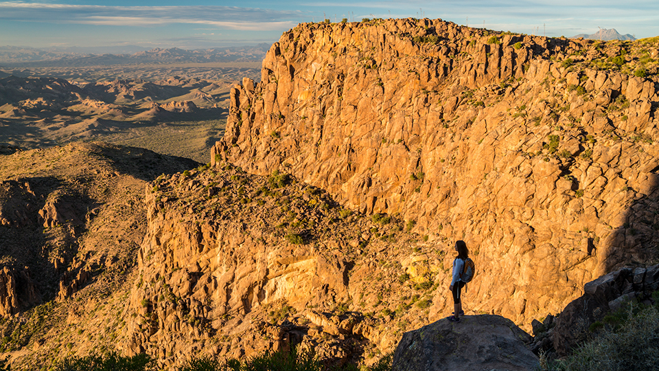
Continuing on, the trail quickly arrives at the Superstition Wilderness, which cradles 160,236 acres, including all of those from this point forward. The line is invisible, but the wilderness boundary is where the wide, easy-to-follow path starts giving way to a narrow, rugged trail that will have you rock-hopping the rest of the day. In the distance, you’ll get your first look at Siphon Draw. And farther on, the Flatiron. If “easy” is the extent of your comfort zone, this is where you’ll turn around. However, if you can handle “moderate,” keep climbing to the basin of the draw. You’ll know it when you see it. It looks like Mother Nature installed an Olympic-sized halfpipe at the foot of the mountain.
The climb through the basin isn’t technical, or very long, but it’s steep and the slick-rock can be iffy. Be careful as you make your way to the saddle at the upper end (elevation: 3,389 feet). This is the turnaround point for Part 1, the Siphon Draw Trail. The rest of the route, Part 2, is the grueling, rock-infested climb to the Flatiron. The gantlet.
The first challenge is getting over the saddle — some minor technical prowess comes in handy. After that, route-finding and conditioning will be your biggest concerns. From the saddle, make your way to the riparian wash on the right. Once in there, the rule of thumb is “Keep left.” Several side trails to the right will try to draw you in, and make things confusing, but resist the temptation. When in doubt, remember: Left is right.
In addition to staying on track, you’ll need to pace yourself. This last mile demands everything you’ve got. It’s an hourlong (at least) slog to the next saddle, which is blocked by an 8-foot wall of rock. After carefully climbing over, it’s an easy scramble to the summit. Your legs will be on fire when you get there, but once you’re standing at the edge of the precipice, taking in the view, it won’t matter. You’ll be glad you ran the gantlet.
Length: 4.28 miles round-trip (6.05 miles round-trip to the Flatiron)
Difficulty: Moderate (strenuous to the Flatiron)
Elevation: 2,058 to 3,389 feet (4,671 at the Flatiron)
Trailhead GPS: N 33˚27.561', W 111˚28.798'
Directions: From Idaho Road in Apache Junction, go east on State Route 88 (the Apache Trail) for 4.8 miles to Lost Dutchman State Park. Proceed to the entrance gate, then follow the signs to the Siphon Draw Trailhead.
Special Consideration: A $7 day pass is required.
Vehicle Requirements: None
Dogs Allowed: Yes
Horses Allowed: No
USGS Map: Goldfield
Information: Lost Dutchman State Park, 480-982-4485 or azstateparks.com/lost-dutchman; Mesa Ranger District, 480-610-3300 or fs.usda.gov/tonto