
South Rim, Grand Canyon National Park
The South Kaibab, which was built in 1924-25 as an alternative to Ralph Cameron’s Bright Angel Toll Road, has been described as “a trail in a hurry to get to the river.” It’s a legitimate characterization. It’s the route most hikers use when they’re going rim to rim or rim to river — they take it because they’re in a hurry. Although it’s a freeway of sorts for long-haul hikers, the South Kaibab is a great option for anyone wanting to experience the Grand Canyon from within. The views from Mather Point, Lipan Point and the many other lookout points are impressive, but they’re even better below the rim.
To hike the entire route — to the river and back — takes about 10 hours (12.5 miles round-trip). But before you lace up, you need to understand that the National Park Service strongly advises against going the distance in a single day. It’s doable, but not if you’re not well conditioned. There are, however, several turnaround points that make great day hikes, including the 2.87-mile route (one way) to Skeleton Point.
From the trailhead at Yaki Point, the South Kaibab kicks off with a series of tight switchbacks. The steep descent, known as The Chimney, is an engineering marvel. Like the slope itself, the price was steep. Overall, the trail cost $73,000. When adjusted for inflation, that would be almost $1.1 million today.
After a quick trip down The Chimney, the trail heads north and levels off somewhat — everything in the Grand Canyon is relative. Along the way, the views start opening up. Then, after about 20 minutes, the well-worn path arrives at the aptly named Ooh Aah Point. It’s the first of an unlimited number of indescribable panoramas.
Moving on, the trail drops down another gantlet of steep switchbacks, and eventually winds around to the right, offering a nice look to the east. From there, it makes its way west to Cedar Ridge — the most popular turnaround point for day hikers.
Like the first resthouse on the Bright Angel Trail, it’s only a mile and a half to Cedar Ridge. There are pit toilets on-site, and hitching posts for the mule trains that move up and down the trail, but there’s no water (there’s no water anywhere along the South Kaibab). There aren’t any cedars, either. It seems the early settlers in the area mistakenly referred to junipers as cedars. To make things even more confusing, most of the scattered trees on the ridge are piñon pines. Not junipers. Not cedars.
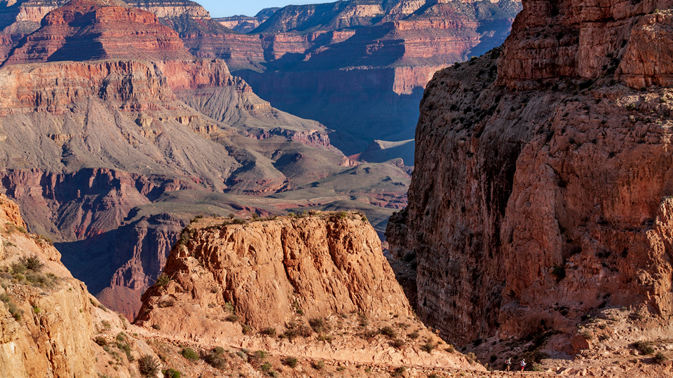
Nevertheless, from “Cedar Ridge,” the trail once again makes a steep descent. This time down the east side of O’Neill Butte. To the right you’ll see Vishnu Temple as you drop to a rare stretch of level terrain and make the final run to Skeleton Point, which gets its name from the unfortunate pack mules that have fallen off the switchbacks below the point.
Known as “The Red and Whites,” the switchbacks drop 500 feet and lead to an intersection with the Tonto Trail, and eventually the Kaibab Suspension Bridge (elevation: 2,400 feet). However, if you heed the warnings of the Park Service and turn around at Skeleton Point, you won’t have to contend with the switchbacks or the extra vertical on the way back up.
From the metal sign at Skeleton Point, take the short spur to the left, which offers long views of Plateau Point, the Phantom Ranch ranger station and campground, Cheops Pyramid, Shiva Temple, Wotans Throne, Cape Royal, and the Colorado River, which is responsible for all of the beauty you’ll see all around you.
“The short distance of this hike is filled with 270-degree views, remarkable floral diversity — Douglas firs to cactuses — and some of the most death-defying trail construction in the park,” says Jack Pennington, the senior program manager for the Grand Canyon Conservancy Field Institute. “It’s one of the most scenic trails in the Canyon.”
It’s also one of the simplest ways to experience the Canyon from within. And that’s something you’ll definitely want to do, sooner or later. Regardless of how far you go, the oohs and aahs are even more abundant below the rim. You’ll see.
Length: 5.74 miles round-trip (to Skeleton Point)
Difficulty: Strenuous
Elevation: 7,198 to 5.158 feet (at Skeleton Point)
Trailhead GPS: N 36˚03.207', W 112˚05.016'
Directions: Access to the trailhead is by shuttle bus only. From the visitors center near Mather Point, take the Kaibab/Rim Route shuttle bus (Orange Route) to the trailhead. The buses leave every 15 to 30 minutes, depending on the time of year.
Special Consideration: National Park Service fees apply.
Vehicle Requirements: None
Dogs Allowed: No
Horses Allowed: No
USGS Map: Phantom Ranch
Information: Backcountry Information Center, Grand Canyon National Park, 928-638-7875 or nps.gov/grca