
Pinaleño Mountains, Safford
Some drives — the ones with long, straight stretches of smooth asphalt — are good to do solo. On those routes, it’s easy to take in the scenery and keep an eye on what’s ahead. No twists and turns. No sheer drop-offs. Just you and the road.
Tripp Canyon Road isn’t one of those drives. This is a trip you’ll want to make with a friend or two, so you can take turns driving. Because while this dirt road near Safford offers jaw-dropping views of the Gila Valley and a quick transition from hot desert to tall pines, it also requires the full attention of whomever’s behind the wheel. But, as you’ll see on this 25-mile jaunt, it’s worth it.
Reset your trip odometer at the Tripp Canyon Road turnoff from U.S. Route 70 in the small community of Pima. After a couple of turns in town, you’ll head west, then southwest, on Tripp Canyon Road, which begins on private property and is quite rough for its first couple of miles. But the ruts soon give way to a smooth, wide road that parallels the northwest flank of the Pinaleño Mountains. Mount Graham (10,695 feet) is this range’s highest (and Arizona’s 13th-highest) peak, but you’re headed to the less-visited, but just as beautiful, west end of the mountains. Farther west, you’ll see the Santa Teresa Mountains, which, like the Pinaleños, are part of the Coronado National Forest.
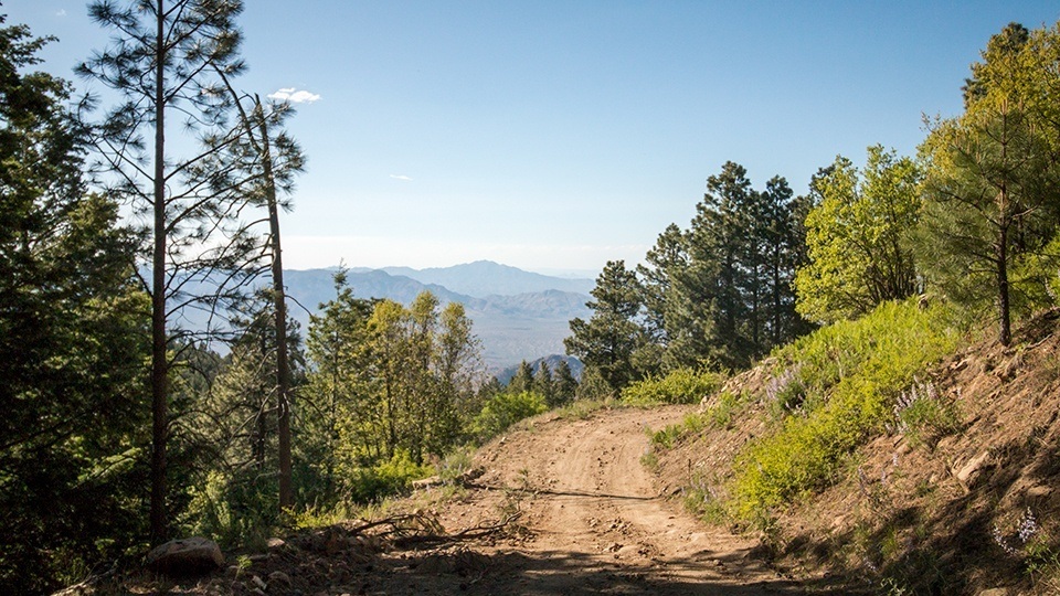
The road begins to climb and gets rougher and narrower around Mile 14, and a mile and a half later, you’ll cross into the national forest, where this route officially becomes Forest Road 286. Soon after, you’ll start to enjoy views, on the right, of the canyon for which this road is named. Oaks and junipers form a verdant riparian area, a dramatic change from the ocotillos and prickly pear cactuses seen earlier in the drive. Around Mile 19, two stately alligator junipers provide shade, and here, the road begins to twist and turn as it moves into a more heavily forested area. Just 2 miles past the junipers, after a significant jump in elevation, you’ll spot the first ponderosa pines, and soon, you’ll see them everywhere — along with big, leafy oaks and assorted small evergreens.
If you’ve been too focused on the curves to notice the views of the Gila Valley up to this point, don’t miss the one at Mile 22.6, as the road turns to the right. Along with the Santa Teresas to the northwest, you’ll see the Gila Mountains to the northeast and the green ribbon of the Gila River cutting across the valley’s floor. Finally, 25 miles from your starting point, you’ll reach this drive’s destination: the Blue Jay Ridge Trailhead, which a wooden sign indicates is 1.5 miles from the 8,645-foot summit of West Peak.
From here, Tripp Canyon Road becomes extremely steep and rough, so you’ll need to four-wheel-drive or hike to the top of the mountain. If you haven’t got four-wheel-drive or calories to spare, just get out, stretch your legs and enjoy the tall trees and cool mountain air. Then, pile back in and get ready for the return trip. Just make sure someone else is driving.
Note: Mileages are approximate.
Length: 25 miles one way (from U.S. Route 70)
Directions: From Safford, go northwest on U.S. Route 70 for 9.5 miles to the turnoff for Tripp Canyon Road. Turn left and continue 0.6 miles to a four-way stop. Turn left onto the unmarked road and continue 0.3 miles to Tripp Canyon Road (also unmarked, but look for a white gate and fence). Turn right onto Tripp Canyon Road, which later becomes Forest Road 286, and continue 24.1 miles to the Blue Jay Ridge Trailhead.
Vehicle requirements: The drive to the trailhead requires a high-clearance vehicle; the remaining 1.5-mile stretch to the top of West Peak requires four-wheel-drive.
Warning: Back-road travel can be hazardous, so be aware of weather and road conditions. Carry plenty of water. Don’t travel alone, and let someone know where you are going and when you plan to return.
Information: Safford Ranger District, 928-428-4150 or www.fs.usda.gov/coronado